This post is a continuation of (or addition to) Kirsch Family Origins. I am currently writing a section for my History of Martha project (tracing the ancestry of my great-grandmother, Martha Kirsch), so much of the text in this post may be copied from that first post about the earliest information I have about the Kirsch family. I realized recently that I tend to write “backwards in time” as I solve genealogical “mysteries” for blog posts, or I start with what I know and then follow clues backwards. In the attempt to rearrange (and add more) information to be more chronological, I may repeat parts of previous posts.
I have a question for those knowledgeable about Polish sources: Do Polish book titles capitalize every word like in English? Thank you. Again, please excuse the inconsistent citations as I try to finalize a (customized) style that works for me.
Finally, a quick note that Wysogotowo will be spelled numerous ways, depending on the original source. Variants will be in quotations to make it less confusing.
Wysogotowo, [before] 1782-1813
The Kirsch family’s paper trail begins with Martha’s great-grandparents in Wysogotowo in the late eighteenth century. Wysogotowo, located eleven kilometers west of Posen (city), was a German colony in the Polish-Lithuanian Commonwealth.[1] At the start of the eighteenth century, various Kirsch family members, including our ancestors, Kazimierz and Elzbieta (Pfeiffer) Kirsch (and little son, Gottlieb), traveled 225 kilometers from Wysogotowo (now in Wielkopolskie, Poland) to Florentynow, Lodzkie, Poland. The paper trail begins with marriage and death records created in the Kirsch family’s new jurisdiction, which sometimes mentioned birthplaces.
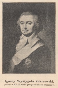
The 1830 marriage record of Gottlieb Kirsch, the oldest child of Kazimierz and Elzbieta Kirsch, and Eva Rozyna Both states that Gottlieb was born in “Wola Wysokotowska” in around 1808 and that his parents were also from there. According to Stanislaw Kozierowski, “Wyssogotowo Oledry” was named for the noble Polish family that founded it, the Wyskotow Zakrzewskich family.[2] The family also founded Zakrzewo Oledry, which is five kilometers from Wysogotowo, “before 1745,” and it is possible the two colonies were founded around the same time.[3] One member of the Wyskotow Zakrzewskich family was Ignacy Wyssogota Zakrzewski, the mayor of Warsaw in 1792 and 1794. In a 1788 Magazin für die neue Historie und Geographie [Magazine of New History and Geography] (volume twenty-two), “Oledry Wysogotowo” had twenty-one “chimneys.”[4] In 1841, the population was 181.[5] Fifteen years later, Wysogotowo, “a village of Prussia, in the regency and [kreis] of Posen” had 200 people.”[6] Meyers Gazetteer (1893 map, not searchable database) includes “Wyssogottowo Hauland.”[7]
Some records mention only “Wola, Grand Duchy of Posen” (the Grand Duchy of Posen existed at the time of the records’ creation, from 1815 to 1848). When Elzbieta Kirsch died in 1847, “Wola” was recorded as her birthplace. She was born in around 1782 to Gottlieb Pfeiffer and Mariana Pelsz.[8] Ten years before her birth, in 1772, the First Partition of Poland shrunk the Polish-Lithuanian Commonwealth, the fringes going to Europe’s three most powerful kingdoms of that time: Russia, Prussia, and Austria. Posen (region), however, remained in the Polish-Lithuanian Commonwealth. By the time Elzbieta’s first son, Gottlieb, was born in Wola in 1808, the Second Partition of Poland (1793) had granted Prussia possession of Posen (region).
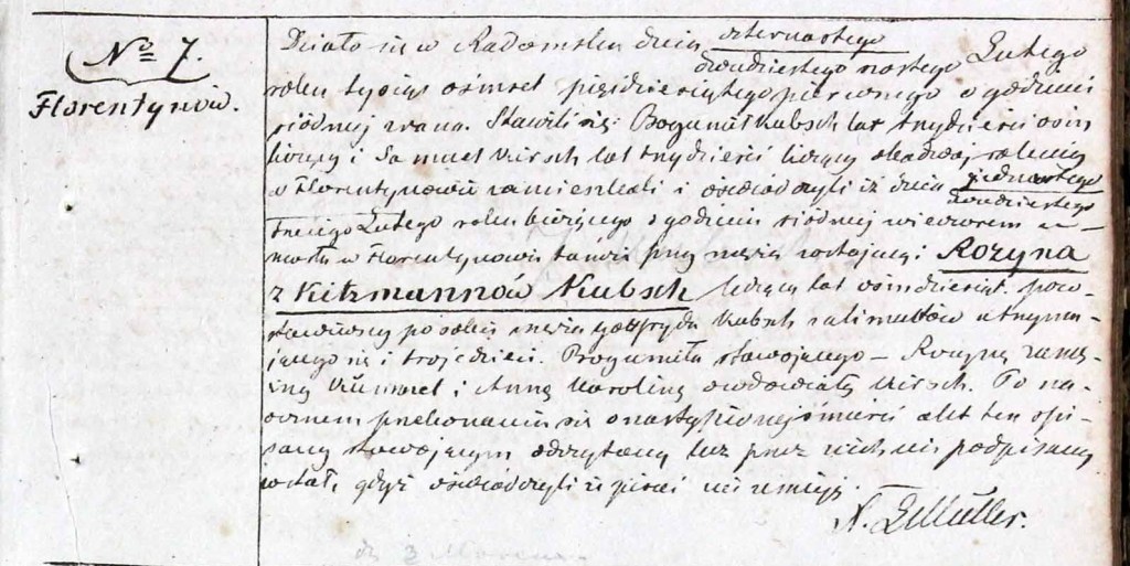
“Wola” appears in other records. Marcin Kirsch, whose precise relation to known Kirsch ancestors is unknown (though likely a close relative), died in Florentynow in 1846 at the age of seventy-eight. His death record names Krystyan Kirsch and Maryanna Elzbieta Has as his parents and “Kolonia Wola in the Kingdom of Prussia” as his birthplace. “Wola” on its own does not indicate a specific location because it refers to a type of settlement. The word “wola” is possibly from the Polish “wolni,” which means “free” and refers to a colony “established at the will of the local gentry or aristocracy” and populated by farmers not bound to the land by serfdom (abolished in Prussia in 1807), but by the agreement to improve it in exchange for certain privileges.[9] The term “wola” has a similar meaning to “hauland,” which is interchangeable with the Polish “holendry” or “oledry.” “Hauland,” which refers to the initial Dutch settlers who arrived in Poland during the sixteenth century, indicated “lease of land, with only cash rent payable to the landowner.”[10] The colonists were also collectively responsible for rent owed to the landowner.
Radomsko, May 11, 1846, 2 o’clock in the afternoon. Declarants: Chrystjan Kirsch, age 63, the brother of the deceased, Gottlib Weber, age 33, both farmers residing in Kolonia Florentynow. Deceased: Yesterday at 10 o’clock in the morning in Florentynow, Marcin Kirsch, residing in Kolonia Wlodzimierz in Parzniewice Commune, renter, died, age 78, born in Kolonia Wola in the Kingdom of Prussia, son of Chrystjan Kirsch and Marjanna Elzbieta Has, married, farmers who died there. Left behind his widowed wife Rozyna Lotka (Lotek) and children: Gottfryd, Marcin, Jakob.
“[Marcin Kirsch death record, 1846]” from Akta stanu cywilnego Filialu Ewangelicko-Augsburskiego w Dziepolci (Dziepolc Civil Records, Evangelical Church of the Augsburg Confession), Archiwum Panstwowe w Lodzi (Lodz State Archives), digitized by Polskie Towarzystwo Genealogiczne (Polish Genealogical Society), accessed 21 Nov 2020 through Geneteka. Translated by Monika Kucal.
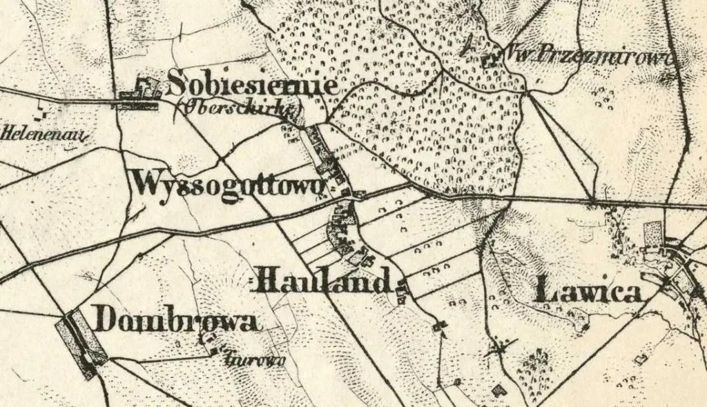
The Kirsch family likely migrated to Wysogotowo during the first half of the eighteenth century. According to historian Walther Maas, many Germans migrated to Posen (region) during the eighteenth century as a result of the devastation following the Great Northern War, a conflict fought mainly between Russia and Sweden and lasting from 1700 to 1721.[11] Plague also claimed the lives of more than half of the inhabitants of Posen (city) in 1708-1709, perhaps killing more people in the region than war.[12] As a result of this population and economic loss–due to war, plague, as well as famine–in the Polish-Lithuanian Commonwealth, the Polish nobility recruited Germans to take their place.[13] These landowners needed cash and benefited from the switch from labour to cash rent.[14] According to Maas, the new German settlements were built on land that had not yet been farmed; the new German settlers had to clear the forests, the incentive being that they were allowed to keep surplus crops.[15] The 1893 map shows Wysogotowo with the typical “hauland” layout: a row of houses along one or both sides of a road with narrow fields behind the houses.[16] The timeline of events and the nature of Wysogotowo’s founding by Polish nobility provides a plausible explanation as to why Kirsch ancestors migrated there, though more information is needed.

[1] Note: Posen is now Poznan, Wielkopolskie (Greater Poland), Poland
[2] Stowarzyszenie Konserwatorow Zabytkow [Association of Monument Conservators], “Names of Oleder Settlements in Wielkopolska: Origins and Changes” from Catalogue of Monuments of Dutch [Oleder] Colonization in Poland, 2005, accessed 18 Nov 2022 through http://holland.org.pl/art.php?kat=art&dzial=konf_2001&id=6&lang=en; Note: Variants of surname are Wyssogota, Wyskota, Wyszogota, and Wyszkota; information from Badania nazw topograficznych na obszarze dawnej wschodniej Wielpolski [Research on Topographic Names in the Area of Former Eastern Wielkopolskie] by Stanislaw Kozierowski, published 1928
[3] Ibid.
[4] Curt [publisher], Magazin für die neue Historie und Geographie [Magazine of New History and Geography] v22, p37, published 1788, accessed 13 Nov 2022 through Google Books
[5] De l’Echaude [publisher], Opisanie geograficzno-historyczno-statystyczne wojewodztwa poznanskiego [Geographical, Historical and Statistical Description of the Poznan Voivodship], p116, published 1841, accessed 13 Nov 2022 through Google Books
[6] A. Fullarton [publisher], A Gazetteer of the World v7, p566, published 1856, accessed 13 Nov 2022 through Google Books
[7] Note: Map is Karte des Deutschen Reiches [Map of the German Empire], published 1893, accessed 22 Nov 2022 through https://www.meyersgaz.org; Digitized map from David Rumsey Map Collection, accessed 22 Nov 2022 through https://www.davidrumsey.com/blog/2011/4/10/karte-des-deutschen-reiches-1893
[8] Note: German Pfeiffer appears as Fayfer in Polish records
[9] PolandGenWeb [copyright], “Place Name Guide” from Lubelskie Genealogy Web, undated, accessed 14 Nov 2020 through http://sites.rootsweb.com/~pollubel/lubelname.html
[10] Stowarzyszenie Konserwatorow Zabytkow [Association of Monument Conservators]
[11] Joel Streich, “HAULAND – its meaning?” [response to Google Group post] from soc.genealogy.german [Google Group], accessed 20 Nov 2022 through https://groups.google.com/g/soc.genealogy.german/c/RCTbhqpwaeU?pli=1; Note: Google Group post references information from Siedlungen an Obra, Bartsch, Prosna und Oberer Warthe, im Leslauer und Tschenstochauer Lande sowie in den Kreisen Bromberg und Wirsitz: Historische und sozialgeographische Studien [Settlements on Obra, Bartsch, Prosna and Oberer Warthe, in Leslauer and Tschenstochauer Land and in the districts of Bromberg and Wirsitz: Historical and Socio-geographical Studies] by Walther Maas, published 1978
[12] Publication of the Archaeological Institute of America [copyright], “18th-Century Plague Victims Unearthed in Medieval Cemetery” from Archaeology Magazine, 24 Jul 2017, accessed 13 Mar 2023 through https://www.archaeology.org/news/5757-170724-poland-plague-victims; Karol Koscielniak, “The impact of the Great Northern War on Poznań and the lives of its inhabitants” from Open Military Studies, 31 Dec 2021, accessed 13 Mar 2023 through https://doi.org/10.1515/openms-2020-0115
[13] William Remus, “Your Ancestors in Volhynia and Poland from 1700 to 1900: How They Got There and How They Lived” [PowerPoint presentation] from Foundation for East European Family History Studies, undated, accessed 20 Nov 2022 through https://feefhs.org/sites/default/files/past_conferences/ancestors-in-volhynia-poland.pdf
[14] Ibid.
[15] Joel Streich.
[16] Karte des Deutschen Reiches [Map of the German Empire]; Joel Streich.