I initially set out to write a longer and more informative post about the Kelm family in Sudbury and Hanmer, Ontario, but wondered if a shorter post stemming from a phone conversation I had with my dad earlier this year might spark some reminiscing (which would then provide more motivation to continue working on the longer article). If you have anything to add from your knowledge or memories of this time, please leave a comment or email me at sarika.rainey@gmail.com. Thank you.
The Queen Visits Sudbury, 1959
My grandfather, Robert Kelm, worked as a nickel miner in Sudbury from around 1937 to his retirement in 1972. I know that his brother, Daniel Kelm (see reference in his 2004 obituary), also worked in the nickel mines, but I otherwise have no information or stories about how they were recruited from Winnipeg to work there.
My grandparents moved the family to an 80-acre farm in Hanmer, Ontario, in 1955. My dad, John Kelm, doesn’t remember the exact location of the family farm, but recalls that you could see the “Falcon Radar Station buildings.”[1] According to RCAF.info, the former RCAF (Royal Canadian Air Force) Falconbridge Radar Station, which opened in 1952, was located between Hanmer and the Greater Sudbury Airport (see map below).[2]
Falconbridge Radar Station operations building looking south, date unknown; photograph shared by RCAF.info (original possibly from the Department of National Defence photographs sub-sub-series, which is part of the Library and Archives Canada’s Department of National Defence fonds)
Google Map showing locations of Sudbury, Hanmer, Greater Sudbury Airport, and possible location of the former Falconbridge Radar Station; coordinates courtesy of RCAF.info
Queen Elizabeth II and Frood Mine manager, E.N. Gaetz, leaving mine; courtesy of The Canadian Press and CBC News
On July 25, 1959, Queen Elizabeth II and her husband, Prince Phillip, visited the Frood Mine [Frood-Stobie Mine] in Sudbury as part of their 45-day tour of Canada: “A mining demonstration was staged for their viewing […] Several hundred people reportedly lined the thoroughfare and song “God Save the Queen” as the Royal couple passed through the mine gates following their visit.”[3] My dad, who was sixteen at the time, remembers that his parents took the family to see the queen (possibly at the airport) and my grandmother took a photo of the children waving.[4]
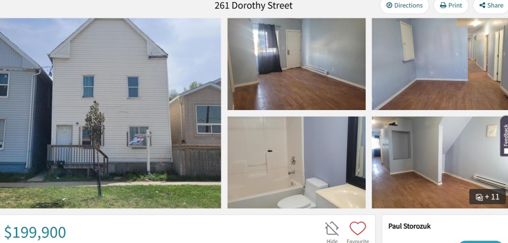
While working on my book, I accidentally found this house listing. For $199,900 CAD, you can buy 261 Dorothy Street (duplex) in Winnipeg, where my great-grandfather, Julius (John) Kelm lived with his first wife, Serafina, and their two children, William and Olga. The house, built in 1905, was mentioned in Serafina’s obituary when she died in 1907 (see Finding Serafina Kelm). When Julius and Martha married in 1910, they moved back to Dorothy Street, though the address is not mentioned (see Stories from the Past: To Marry or Not to Marry) and I could not find them living on Dorothy Street in the 1911 Census of Canada. Dorothy Street is just south of the Canadian Pacific Railway (CPR) yards and, historically, seemed to have been comprised of rooming houses. In the 1911 census, for example, 261 Dorothy Street housed 26 people.
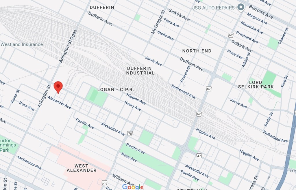
Google Map of Dorothy Street with reference to the CPR railway yards in Winnipeg
In 2011, the City of Winnipeg’s Board of Adjustment reviewed (view PDF here) the proposed “redevelopment of the boarded up, burnt out, former rooming house into a two family dwelling unit.” According to the report, a fire on August 11, 2008, damaged the exterior walls, floors, and roof (you can see footage of the house in this video of fire crews extinguishing a fire at 257 Dorothy Street in 2015) and the building was placed on the Vacant Building Registry. While the interior might look very different than it did 118 years ago (the interior was apparently gutted in 2011), I think the opportunity to glimpse at the inside of the house now can still offer clues as to what it was like when our ancestors lived there (for example, see the little rooms off the hallway in the top right corner of the first image).
My apologies for the pause in updates. I am planning a wedding (and other major life events) and have had little time outside of work to enjoy the quietness of genealogy research. My updates may be scant for a few months, but I am try to work on my book when I can. I will also try to share excerpts of that work in progress here when I can, such as this post about Kirsch family origins. This section took almost a year to write. There is a lot of persistence that goes into digging for information that you can only suspect is there. Sometimes luck is what ultimately helps you. I need to say a big thank you to the volunteer translators at the Genealogical Translations Facebook group. Without their dedication, I would not have been able to decipher and translate any of the records I find. I am eternally thankful for help, not only with translating, but with helping me understand the structure of certain records so that I know where in the record to find a specific piece of information.
If you need a very general guide about who certain mentioned individuals are, the Direct Ancestors page (scroll down to Kirsch Ancestors and then to the earliest ancestors at the end) might be helpful.
Kirsch Family Origins
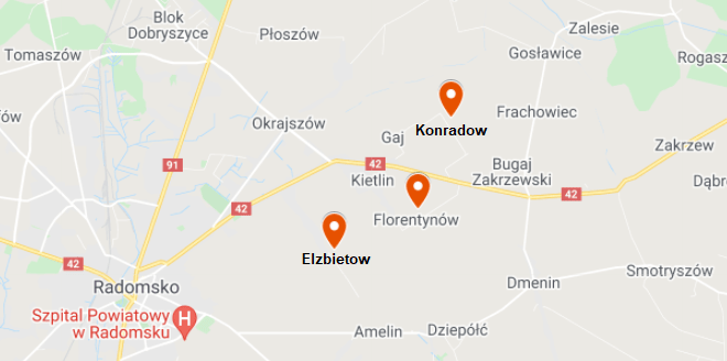
The arrival of German Lutherans in the area around the city of Radomsko (approximately ninety kilometers south of Lodz) in central Poland resulted in the founding of many German colonies, including those relevant to the Kirsch family; Florentynow, Elzbietow, and Konradow were founded in 1809.[1] In 1835, there were twelve colonists living in Florentynow with their families, which numbered ninety in total. [2] In Elzbietow, there were five colonists with forty-five in their families. [3] In Konradow, eleven colonists and sixty-six in their families.[4]
Modern map showing city of Radomsko, Poland, with nearby German colonies of Florentynow, Elzbietow, and Konradow indicated. Created 22 Aug 2021 with Google Maps. For scale, the distance between Elzbietow and Konradow is approximately 3.4 kilometers
The Kirsch families, as well as related families (Wurfel, Kubsch, and Hansch), were among the first settlers in the Radomsko area. Martha’s grandfather, Krzysztof Kirsch, was the first of his siblings born in Florentynow in 1813. Anna Rozyna Kirsch, the daughter of Krystyan Kirsch (unconfirmed but likely relation to Krzysztof) and Anna Dorota Kluske, was born in Florentynow in 1812. Martha’s maternal grandfather, Jerzy Wurfel, was born in Konradow in early 1810 and the family appears to have lived in Elzbietow from 1814. The 1935 Breyer Map by historian Albert Breyer, from an article titled “Deutsche Gaue in Mittelpolen [German Districts in Central Poland]” shows German colonization of central Poland by origin. Florentynow, Elzbietow, and Konradow fall within a region of colonies founded predominantly by those from the province of Silesia.[5] However, the families that settled in these colonies in particular (and eventually intermarried) were from German colonies near the city of Posen, which is in the province of Posen and north of Silesia.
When Krzysztof’s mother, Maria Elzbieta Pfeiffer (also Fayfer), died in Florentynow in 1847, her death record (click here for record and translation) recorded that she was from “Wola, Grand Duchy of Posen, Kingdom of Prussia.” Marcin Kirsch, likely a relation to Krzysztof’s father, Kazimierz Kirsch, died in Florentynow in 1846. His death record names Krystyan Kirsch and Maryanna Elzbieta Has as his parents and his birthplace as Wola, Grand Duchy of Posen, Kingdom of Prussia. “Wola,” which on its own denotes a type of settlement and is not specific enough to confirm which settlement, also appears in other records. According to Meyers Gazeteer (based on an 1871-1912 map of Germany), there were several locations containing “Wola” in Posen, including Wola Lagiewnik, Wola Skorzencin, and Wola Wapowska.
“[Gotlib Wisnieski and Ewa Rozyna Bot marriage record, 1830]” from Akta stanu cywilnego Parafii Rzymskokatolickiej w Kodrąbiu, accessed 22 Aug 2021 through Geneteka; “Wola Wysokotowska” highlighted
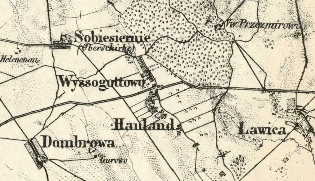
One record specifies a specific “Wola”; the 1830 marriage record of Gottlieb Kirsch, the oldest child of Kazimierz Kirsch and Maria Elzbieta Pfeiffer, and Eva Rozyna Both states that Gottlieb was born in Wola Wysokotowska in around 1808 and that his parents were also from there. Meyers Gazeteer (map, not searchable database) includes “Wyssogottowo Hauland,” Posen, Prussia (now Wysogotowo, Poland). Between Gotlieb’s birth in Wola Wysokotowska and his brother Krzysztof’s birth in Florentynow in 1813, the family migrated approximately 225 kilometers west from just outside the city of Posen.
During the eighteenth century, the ancestors of the Kirsch family would have settled in Wola Wysokotowska or Wyssogottowo Hauland as Haulanders (also Hollanders or Oleders, depending on the language), free farmers (not serfs) who were collectively responsible for rent paid to their landlords.[6] The term “wola,” possibly from the Polish “wolni,” meaning “free,” has a similar definition in that it refers to a settlement or colony “established at the will of the local gentry or aristocracy” and populated by farmers not bound to the land by serfdom, but by the agreement to improve it in exchange for certain privileges.[7] The Wurfel and Kubsch families, though also from Posen and not Silesia, were from Chrzastowo, Schrimm, approximately thirty-seven kilometers south of Posen (city). It is still unknown where the Hansch (Julianna Hansch is Martha Kirsch’s maternal grandmother) family originated, but Julianna’s parents, and Martha’s great-grandparents, Andrzej Hansch and Anna Fryderyka Wolf, lived in Konradow from around 1815.
The Kirsch, Wurfel, and Kubsch families lived in what was the Polish-Lithuanian Commonwealth, which lasted approximately from 1569 to 1795, until the Second Partition of Poland in 1793, when Posen became part of Prussia.[8] After Prussia snatched their share of the former Polish-Lithuanian Commonwealth, Prussia imposed several Germanification policies in the newly-acquired corners of their empire. German colonists were encouraged to migrate further east, which may be why the families helped found colonies around Radomsko. However, these borders kept changing. In 1807, Napoleon Bonaparte, during his Napoleonic Wars, created the Duchy of Warsaw (also known as Napoleonic Poland), which included both the colonies of origin near Posen and the forthcoming colonies near Radomsko. In 1815, after the Napoleonic Wars, the Duchy of Warsaw was divided into the Grand Duchy of Posen (Prussia) and Congress Poland (Russia). The Polish people were granted some autonomy, which was why many records were in Polish. By the 1860s, as Polish uprisings caused Russia to restrict Polish freedom, there is a shift to Russian.[9]The Florentynow Population book, for example, was created in around 1866 and so contains records in both Polish and Russian.
Modern map showing migrations of Kirsch generations from the eighteenth-century up until Martha Kirsch migrated to Winnipeg, Canada, in 1908. Created 22 Aug 2021 with Google Maps
[2] Marcus König, “Lage und Orte [Location and Places]“ from Deutsche Familien aus dem Kreis Radomsko,” undated, accessed 23 Oct 2020 through http://www.radomsko.de/14401.html
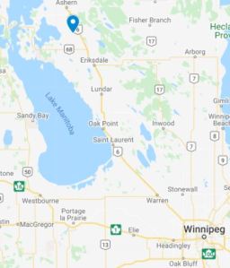
Map showing Winnipeg (bottom right) and the location of the Kelm homestead near Camper (top left)
When Robert Bergner arrived in Camper on June 13, 1910, to look for a homestead, “there was no town, only a few tents.” Though described as historically having been “an uninhabited wilderness” or having few permanent settlements by the late eighteenth century,[1] the Interlake region of Manitoba, between Lake Manitoba and Lake Winnipeg, was home to the Ojibway, Cree, and Oji-Cree, as well as the Metis.[2] From 1670 to 1869, the region was part of Rupert’s Land, which comprised eight million square kilometers and was monopolized by the Hudson’s Bay Company. In 1869, the Government of Canada purchased Rupert’s Land from the HBC, who claimed ownership, for 1.5 million dollars. The transfer was finalized in 1870, the same year Manitoba joined Canada.
Starting in 1871, the Government of Canada established townships in a grid system called the Dominion Land Survey. Beginning in 1872, The Dominion Land Act guided the administration of land for homesteading, among other uses. To boost prairie settlement, the government advertisement homesteads in 160-acre increments. After paying the ten-dollar application fee, the homesteader had three years to break and farm thirty acres of land, reside on the homestead for more than six months out of the year, and build a house and barn.[3] Once these requirements were fulfilled, the homesteader would receive the title for the land and, if he was not already a British subject, become naturalized.[4]
Julius Kelm applied to the Government of Canada for a homestead on May 1, 1911.[5] The 164 acres was located along what is now Edison Road, approximately halfway between Highway 6 and Dog Lake, and six kilometers from Camper.[6] According to an interview with Julius and Martha (see Stories From the Past), there were around twenty other German families living in the area around Camper. The majority of Germans settled north and east of Dog Lake and west of Camper: “Many of the later [German] settlers–from the Russian Ukraine–came to be near the earlier German settlers and took up stonier, more heavily-wooded land.”[7]
“[Julius Kelm entry in Homestead Grant Register, application for homestead 419750]” in Manitoba, Saskatchewan and Alberta, Canada, Homestead Grant Registers, 1872-1930, Library and Archives Canada, accessed 05 Jun 2021 through Ancestry
Julius likely traveled the 165 kilometers from Winnipeg to Camper alone to look at available land before applying for it. There were few roads during that time; scouting homesteaders only had “a map from the Land Titles Office, showing the township lines, which were just lines just cut through the bush; [they] walked through swamps waist deep in water.”[8] Julius would have returned to Winnipeg for his family. Anna Markwart recalls that, in 1909, the Markwart family “packed up their belongings, loaded them into a freight car and came by rail as far Camper [as] that was as far as the railway went at that time. They had to stay in the freight car while Henry [Markwart] walked seven miles [eleven kilometers] to the homestead to see if he could get the only neighbor to lend him a wagon to move the family to the new homestead.”[9] Julius had selected land “in the twenty-third township, in the sixth range, west of the principal meridian,” or homestead 419750.[10]
The first of the homesteading work occurred in early May. The land would have to be broken and ploughed first, and this was most effectively accomplished between June and August. Many accounts of homesteading in the Camper area begrudge the “mountains of stones”; in order for land to be cleared for farming, “stumps and stones” had to be removed and “every time the land was ploughed there would be more stones.”[11] After this, a house and stable would be built. Anna Markwart remembers that her husband’s family “lived in a makeshift shelter until they could cut enough logs for a small log house.”[12]
Homesteading on the prairie was often treacherous; wild animals harassed and feasted on livestock, even getting into the barns.[13] The year Julius secured his homestead, a timber, or grey, wolf was terrorizing livestock “from Camper to Gypsumville” and farmers would stay up at night with their guns waiting for it.[14] The prairie, immense and seemingly never-ending, could also be a lonely place. Debbie Hoffman describes her grandmother’s, Martha Miller’s, first years in her new home: “Martha wasn’t used to the big forests and swamps of the Interlakes […] The fright and loneliness almost drove her out of her mind.”[15]
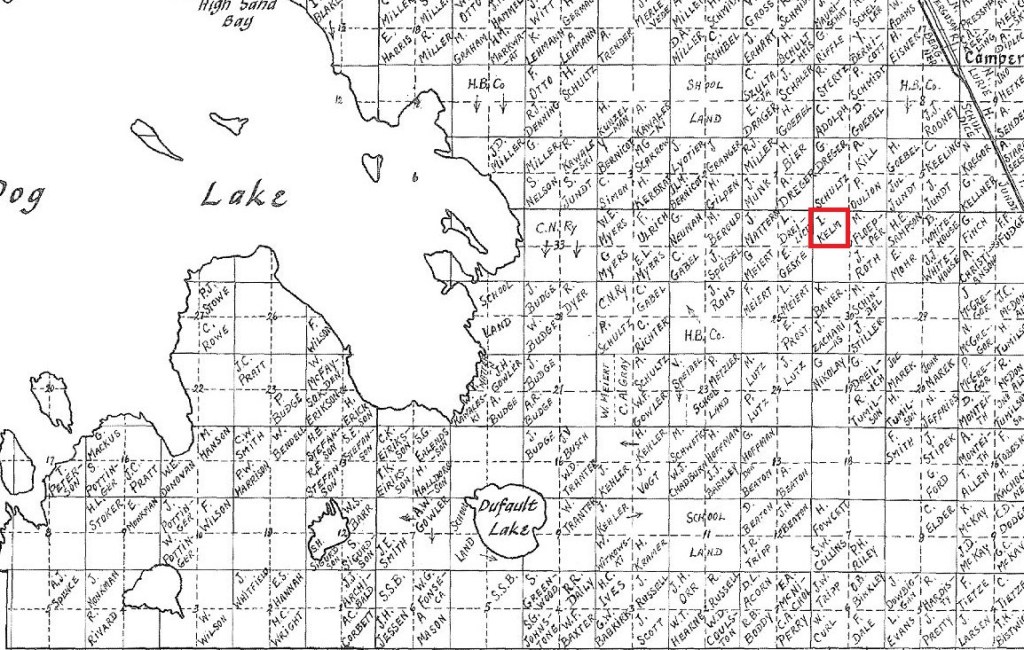
Map of homesteads located within Township 23, east of Dog Lake. Julius Kelm’s neighbors included the Drailich family, whose daughter Adeline “Lena” married Edward Kelm, and Mattern and Geske families; courtesy of Taming a Wilderness: A History of Ashern and District by Ashern Historical Society
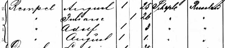
Julius and Martha had four children while living near Camper: Hannah (born March 4, 1913), Robert (born May 12, 1914), Hilda (born June 22, 1915), and Daniel (born May 17, 1917). The place of birth for the first three children is the Rural Municipality of Coldwell while the place of birth for Daniel is Camper.[16] In the 1916 Census of Canada, the family identified as Russian as World War One raged in Europe, the German families around them also identifying as Russian.[17] Julius (as John Kelm) also appears in the 1916 Census of Canada living with the Rempel family at 814 Bannatyne in Winnipeg as a lodger. He may have returned to Winnipeg for part of the year to find extra work to sustain his homestead.[18] Later that year, in December, the oldest daughter, Olga, thirteen years old, died. No record has been found of her death and burial.
It took Julius and Martha more than three years to earn their papers. Julius owned the land by February 15, 1917, when inspectors verified that he had fulfilled the requirements.[19] Sworn statements from two neighbors were required.[20] When his neighbor John Mattern, obtained the patents to his land on May 20, 1918, Julius testified: “Those that witnessed this were John Kelm of NW 31-23-6W and Edward Geske of SE 36-23-7W.”[21] In the 1921 Census of Canada, Julius is the owner of his three-room home.[22]
[Homestead No. 419750 grant]” from Letters Patent, Canada, Department of the Interior, accessed 05 Jun 2021 through Canadiana Heritage
But farming proved to be too difficult; the Kelm family “had the worse land, unsuitable for farming” (see Stories From the Past). Frank Tennenhouse, whose family moved to Camper in 1911, writes that there was little government support for new farmers and there were few nearby farmers who had settled there long enough who could help newcomers.[23] Tennenhouse remembers that his father had “visited the location and had thought it was wonderful because there was plenty of hay for cattle and trees for wood. What he did now know was that the hay was low quality swamp and the soil was stony and infertile.”[24] Shannon Stunden writes, “Many […] newcomers settled in the less productive lands […] in eastern or interlake Manitoba.”[25] Most families returned to Winnipeg.
[1] James Morton Richtik, “A Historical Geography of the Interlake Area of Manitoba [thesis]” from Manitoba Heritage Theses, University of Manitoba, 1964, p14
[5] “[Julius Kelm entry in Homestead Grant Register, application for homestead 419750]” in Manitoba, Saskatchewan and Alberta, Canada, Homestead Grant Registers, 1872-1930, Library and Archives Canada, accessed 05 Jun 2021 through Ancestry
[13] Dugald Women’s Institute, Springfield: 1st Rural Municipality in Manitoba, 1873-1973, Dugald, MB: Dugald Women’s Institute, 1974, p34, accessed through Internet Archive
[14] Interlake Pioneers, Hardship and Happiness, Steep Rock, MB: Interlake Pioneers, 1974, p64
[19] “[Homestead No. 419750 grant]” from Letters Patent, Canada, Department of the Interior, accessed 05 Jun 2021 through Canadiana Heritage; the stamp in the homestead grant register indicates February 7, 1917
[20] “Manitoba Crown Land and Homestead Records (National Institute) [wiki]”
[21] Ashern Historical Society: The Next Chapter; A History of Ashern and District, Ashern, MB: Ashern Historical Society, 2008, p319, accessed 06 Jun 2021 through University of Manitoba Digital Collections
[22] 1921 Census of Canada, Library and Archives Canada, accessed 08 Jun 2021 through Ancestry
[23] Frank Tennenhouse, “Photocopy of unpublished manuscript, “Seventy Five Years of Farming in Manitoba: A Collection of Stories of Life on the Farm from Two Generations of the Tennenhouse Family,” Tennenhouse Family fonds, University of Manitoba Archives, accessed 06 Jun 2021 through University of Manitoba Digital Collections
[25] Shannon Stunden Bower, Wet Prairie: People, Land, and Water in Agricultural Manitoba, Vancouver: University of British Columbia Press, 2011, p35, accessed 08 Jun through Google Books
It took me a surprisingly long time to understand where on a map my family history was taking place. I had yet to realize that having even a “work in progress” understanding of the regions I was researching would be as helpful as it is. Perhaps I didn’t bother to orient myself right away because I was intimidated by the everchanging European borders of the seventeenth and eighteenth centuries. [Note: The blog post, “Those Infamous Border Changes: A Crash Course in Polish History,” from From Shepherds and Shoemakers is a thorough yet concise overview of Polish border changes]. In this blog entry I will first try to explain how I understand the geographical terms and then provide a visual guide to what locations I write about with regards to the Kirsch family (see Kirsch Research page) in Volhynia. I should preface with the disclaimer that I am still learning and this is the way I currently understand it. Corrections are appreciated and I probably need to revisit previous blog entries to make corrections based on new knowledge.
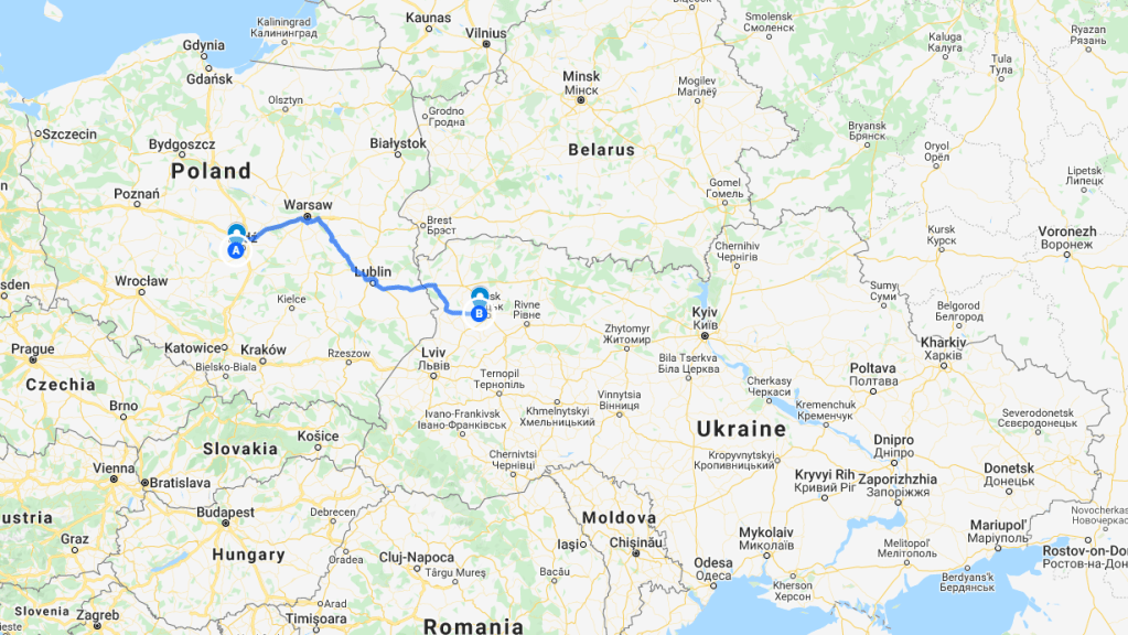
My great-great-grandfather, Samuel Kirsch, traveled with his family from Florentynow (colony or village), Lodzkie (voivodeship = province), Poland (country), to Rozyszcze (parish), Lutsk (raion = district), Volhynia (oblast = province or region), Russia (country), in around 1867. The journey from what is now central Poland to western Ukraine was more than 500 kilometers. [Note: I use the terms “colony” and “village” interchangeably because I am often referring to communities established in Congress Poland and Volhynia by German colonists]. The Kirsch family had lived in Florentynow since at least 1813, the recorded year of birth of Samuel’s father, Krzysztof Kirsch. Before then, the family lived in Wola (colony or village), Grand Duchy of Posen, Kingdom of Prussia (the precise location of Wola is currently unknown, but you can see Posen city, or Poznan, on the map below, west of Point A).
Map 1: Map of journey on a current map of Poland and Ukraine, created 21 Mar 2021 using Google MyMaps; Volhynia of the late nineteenth century spanned southeast Poland and northeast Ukraine
Samuel and his family first settled in Konstantynow (colony or village), Rozyszcze, Lutsk, Volhynia. Samuel’s seventh child, Daniel, was born in Konstantynow, August 22, 1874. Samuel moved ten kilometers to Ludwischin (colony or village) between 1874 and 1877–assumed because his other eleven children were born there, the first being Karl, born March 27, 1877. I often refer to Ludwischin as Ludwischin-Scheppel, which is sometimes how I see it written. The community of Scheppel is located approximately two kilometers north of Ludwischin.
[Note: Refer to Kirsch Research for a list of names; all the Kirsch names in this paragraph are children of Samuel Kirsch unless otherwise noted] Scheppel is where Gottlieb Kirsch was confirmed in the Lutheran church in 1882.[1] But the community has Baptist associations as well. August Rempel and Julianna Kirsch Rempel emigrated from Scheppel with other Baptist families in 1890.[2] Daniel Kirsch’s wife, Wanda Schindler, was from Ludwischin, but her father and two of her sibling were of the Baptist group that traveled from Scheppel aboard the Hansa.[5] According to In the Midst of Wolves by Donald Miller, Scheppel was a Baptist station in Rozyzscze (parish). While Rozyzscze city was home to the largest Baptist church in the parish, there were several “stations” established as the Baptists grew in number in Volhynia, including Scheppel, where people from various communities congregated to worship.[4] Some of these stations became self-supporting churches. Other names for Scheppel are Schepel, Schepek, Schöpel, Schlepe, Szepel, and Schelpe.[5]
“[Rempel family in Hansa ship manifest, 1890]” from Hamburg Passenger Lists, 1850-1934, accessed 20 Mar2021 through Ancestry; the Rempel family is from “Scheple, Russland”
There is evidence that the Kirsch family moved to the nearby colony, Wsewolodowka, between 1902 (death of Adolf Kirsch in Ludwischin) and 1905 (birth of eighteenth and last child, Olga, in Wsewolodowka).[6] Karl Kirsch’s residence was Wsewolodowka when he emigrated in 1913 [Update: Karl lived in Wladislowka, which is a different colony].[7] His four children were also born there (1901, 1905, 1909, 1911).[8]
Finally, Friedrich Kirsch was born in “Marienovka Usicze,” or what I think is nearby Usicze, in 1899.[9]
Tracking geographic locations as they appear in various records against a timeline helps me determine where the family was during major migrations and important historical events. This information helps me construct a narrative, to help tell a story that is more than names and dates. It will also help with future research–for example, where did remaining Kirsch family members go during the deportation of Volhynian Germans in 1915. Knowing where they were living around that date could help find answers.
[1] [“Gottlieb Kirsch confirmation record, 1883”] from VKP Birth & Confirmation Records, accessed 21 Mar 2021 through Society for German Genealogy in Eastern Europe
[2] [“Rempel family in Hansa ship manifest, 1890”] from Hamburg Passenger Lists, 1850-1934, accessed 20 Mar 2021 through Ancestry
[4] Miller, Donald N., In the Midst of Wolves: A History of German Baptists in Volhynia, Russia, 1863-1943, Portland, OR: Multnomah Printing, 2000
[6] [“Olga Kirsch birth record, 1905”] from Volhynia Indexes 1900-1918, accessed 21 Mar 2021 through Society for German Genealogy in Eastern Europe
[7] “Karl Kirsch” in Hamburg Passenger Lists, 1850-1934, accessed 21 Mar 2021 through Ancestry
[8] [“Kirsch family in Stockport ship manifest, 1921”] from Hamburg Passenger Lists, 1850-1934, accessed 21 Mar 2021 through Ancestry
[9] [“Friedrich Kirsch birth record, 1899”] from VKP Birth & Confirmation Records, accessed 21 Mar 2021 through Society for German Genealogy in Eastern Europe